


2017___le_havre_en_plus

doudet
User
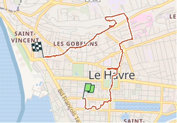

Length
4.2 km

Max alt
89 m

Uphill gradient
90 m
Km-Effort
5.4 km

Min alt
4 m

Downhill gradient
89 m
Boucle
No
Creation date :
2019-07-02 06:29:53.866
Updated on :
2019-07-02 06:29:53.866
--
Difficulty : Unknown

FREE GPS app for hiking
 SityTrail
IGN / Geographical institutes
SityTrail Plus
The world is yours!
About
Trail Walking of 4.2 km to be discovered at Normandy, Seine-Maritime, Le Havre. This trail is proposed by doudet.
Positioning
Country:
France
Region :
Normandy
Department/Province :
Seine-Maritime
Municipality :
Le Havre
Location:
Unknown
Start:(Dec)
Start:(UTM)
290207 ; 5486094 (31U) N.
Comments